Island-on-Map.com The Free Beach Guide HomeCountriesMenu

Sal island

Ultimate guide (March 2024)
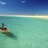
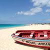
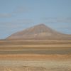
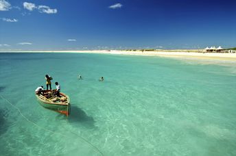
Sal - island with the best beaches in Cape Verde. In general, the island is flat with poor vegetation. Shore and seabed: sand. [edit]
This island ranks #10 of the "Best islands in Africa"
Rating: 7.6 - 945 votes [vote]
Coordinates: 16.670528, -22.916405
See also: Best beaches in Sal island

Hotels [edit]

All hotels are located in the south of island. Range of accommodation is very wide - from cheap guesthouses to luxury beach hotels. Average price level is low in general.

How to get there [edit]

Fly to Sal Island International Airport (SID). Next hire a taxi.

When to go [edit]

From June to December, as in this period the sea water warms up to a relatively comfortable temperature.

Rainfall, mm
Rainfall, mm

Water temperature, C

Temperature, C
Temperature, C

Humidity, %
Humidity, %

Wind speed, meter/sec

Open map

See also other islands nearby:

 
Cape Verde, Boa Vista island, Santa Maria beach, shipwreck 6.9
65 km to the south
Location: Africa, Cape Verde
Rating: 6.9 (2634 votes)
Spain, Canary Islands, Tenerife island, Las Teresitas beach 8.1
1450 km to the north-east
Location: Europe, Spain, Canary Islands
Rating: 8.1 (264 votes)
Spain, Canary Islands, Gran Canaria island, Maspalomas dunas 8.1
1460 km to the north-east
Location: Europe, Spain, Canary Islands
Rating: 8.1 (171 votes)
Spain, Canary Islands, Fuerteventura island, Sotavento windsurfing 7.7
1580 km to the north-east
Location: Europe, Spain, Canary Islands
Rating: 7.7 (423 votes)
Portugal, Madeira islands, mountains 7.7
1890 km to the north
Location: Europe, Portugal
Rating: 7.7 (656 votes)
💖
If you liked this page, please share it on: Facebook, Twitter, Instagram
…or any other web-site
 
This will help the project greatly!

 
To the top of this page »
 
© 2024, Island-on-Map.com · Menu