Island-on-Map.com The Free Beach Guide HomeCountriesMenu

Grande Comore island (Ngazidja)

Ultimate guide (April 2024)
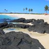
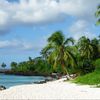
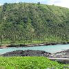
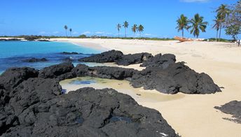
Grande Comore - is the largest of the Comoros islands. The island almost has no normal beaches, but there is the most dangerous volcano in the world (Karthala volcano). Shore and seabed: rocks, sand. [edit]
This island ranks #8 of the "Best islands in Africa"
Rating: 8.0 - 727 votes [vote]
Coordinates: -11.692104, 43.350734
See also: Best beaches in Grande Comore island

Hotels [edit]

Comoros has extremely poor choice of hotels available for booking via international reservations system. In many cases, the only way is to email directly to the hotel owner.

How to get there [edit]

Fly to Comoros International Airport (HAH).

When to go [edit]

The best time to visit the Comoros islands is a dry season from May to November.

Rainfall, mm
Rainfall, mm

Water temperature, C

Temperature, C
Temperature, C

Humidity, %
Humidity, %

Wind speed, meter/sec

Open map

See also other islands nearby:

 
Comoros, Moheli island (Mwali), aerial view 7.1
82 km to the south-east
Location: Africa, Comoros
Rating: 7.1 (720 votes)
Comoros, Anjouan island (Nzwani), ships in bay 7.6
130 km to the south-east
Location: Africa, Comoros
Rating: 7.6 (1037 votes)
Mayotte island, Sada town 7.7
230 km to the south-east
Location: Indian Ocean
Rating: 7.7 (698 votes)
Mozambique, Quirimbas, Vamizi Island 8.3
300 km to the west
Location: Africa, Mozambique
Rating: 8.3 (180 votes)
Tanzania, Mafia island, Lua Cheia beach 8.4
580 km to the north-west
Location: Africa, Tanzania
Rating: 8.4 (329 votes)
💖
If you liked this page, please share it on: Facebook, Twitter, Instagram
…or any other web-site
 
This will help the project greatly!

 
To the top of this page »
 
© 2024, Island-on-Map.com · Menu