Island-on-Map.com The Free Beach Guide HomeCountriesMenu

Fuerteventura island

Ultimate guide (April 2024)
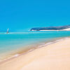
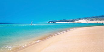
Fuerteventura - spanish island with the best beaches in the Canary Islands. Also popular as a surf destination. Beach and seabed: sand, stones. [edit]
This island ranks #3 of the "Best islands in Canary Islands"
Rating: 7.7 - 426 votes [vote]
Coordinates: 28.37086, -14.108033
See also: Best beaches in Fuerteventura island

Hotels [edit]

There are lots of hotels on the island, including very budget. But in high season it's better to book accommodation in advance.

How to get there [edit]

Fly to Fuerteventura Airport (FUE). Continue by taxi or rent a car. Also bus service is well developed on the island.

When to go [edit]

Sea water is warmest in August. If you are looking for surf, the most strong wind is in the summer.

Rainfall, mm
Rainfall, mm

Water temperature, C

Temperature, C
Temperature, C

Humidity, %
Humidity, %

Wind speed, meter/sec

Open map

See also other islands nearby:

 
Spain, Canary Islands, Gran Canaria island, Maspalomas dunas 8.1
150 km to the west
Location: Europe, Spain, Canary Islands
Rating: 8.1 (184 votes)
Spain, Canary Islands, Tenerife island, Las Teresitas beach 8.1
240 km to the west
Location: Europe, Spain, Canary Islands
Rating: 8.1 (269 votes)
Portugal, Madeira islands, mountains 7.7
550 km to the north-west
Location: Europe, Portugal
Rating: 7.7 (670 votes)
Azores, Sao Miguel island, Vila Franca beach 6.0
1490 km to the north-west
Location: Europe, Portugal, Azores
Rating: 6.0 (517 votes)
Cape Verde, Sal island, clear water 7.6
Sal / open » /
1580 km to the south-west
Location: Africa, Cape Verde
Rating: 7.6 (978 votes)
💖
If you liked this page, please share it on: Facebook, Twitter, Instagram
…or any other web-site
 
This will help the project greatly!

 
To the top of this page »
 
© 2024, Island-on-Map.com · Menu