Island-on-Map.com The Free Beach Guide HomeCountriesMenu

Boa Vista island

Ultimate guide (April 2024)
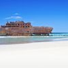
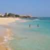
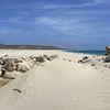
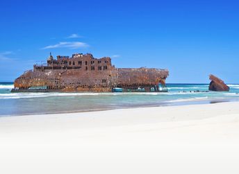
Boa Vista - island in Cape Verde with plenty of deserted beaches. However, the overall quality of beaches is rather mediocre. Shore and seabed: sand. [edit]
This island ranks #2 of the "Best islands in Cape Verde"
Rating: 6.9 - 2676 votes [vote]
Coordinates: 16.094701, -22.817478
See also: Best beaches in Boa Vista island

Hotels [edit]

Most hotels are located in the north-west of the island - near the airport. In general price level is quite high.

How to get there [edit]

Fly to Boa Vista International Airport (BVC). Next hire a taxi.

When to go [edit]

Any time, except for the cool season in January-May.

Rainfall, mm
Rainfall, mm

Water temperature, C

Temperature, C
Temperature, C

Humidity, %
Humidity, %

Wind speed, meter/sec

Open map

See also other islands nearby:

 
Cape Verde, Sal island, clear water 7.6
Sal / open » /
65 km to the north
Location: Africa, Cape Verde
Rating: 7.6 (978 votes)
Spain, Canary Islands, Tenerife island, Las Teresitas beach 8.1
1500 km to the north-east
Location: Europe, Spain, Canary Islands
Rating: 8.1 (269 votes)
Spain, Canary Islands, Gran Canaria island, Maspalomas dunas 8.1
1510 km to the north-east
Location: Europe, Spain, Canary Islands
Rating: 8.1 (184 votes)
Spain, Canary Islands, Fuerteventura island, Sotavento windsurfing 7.7
1630 km to the north-east
Location: Europe, Spain, Canary Islands
Rating: 7.7 (426 votes)
Portugal, Madeira islands, mountains 7.7
1950 km to the north
Location: Europe, Portugal
Rating: 7.7 (670 votes)
💖
If you liked this page, please share it on: Facebook, Twitter, Instagram
…or any other web-site
 
This will help the project greatly!

 
To the top of this page »
 
© 2024, Island-on-Map.com · Menu