Island-on-Map.com The Free Beach Guide HomeCountriesMenu

Anjouan island (Nzwani)

Ultimate guide (March 2024)
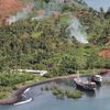
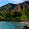
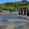
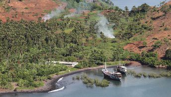
Anjouan - is the second largest island of Comoros. There are no beaches at all, though it is possible to find small spots of coastline suitable for swimming. Shore and seabed: rocks, sand. [edit]
This island ranks #2 of the "Best islands in Comoros"
Rating: 7.6 - 1007 votes [vote]
Coordinates: -12.221662, 44.41133
See also: Best beaches in Anjouan island

Hotels [edit]

Anjouan is an agricultural island, so there are few small hotels only. You can always find a room when you arrive to the island at: Hotel Al Amal, La Papilon, Hotel Maponge, Hotel Johana living stone & Hotel Karama.

How to get there [edit]

Fly to Comoros International Airport (HAH). Next take a domestic flight to Anjouan island airport (AJN). There are also some international flights to Anjouan island.

When to go [edit]

The best time to visit the Comoros islands is a dry season from April to November.

Rainfall, mm
Rainfall, mm

Water temperature, C

Temperature, C
Temperature, C

Humidity, %
Humidity, %

Wind speed, meter/sec

Open map

See also other islands nearby:

 
Comoros, Moheli island (Mwali), aerial view 7.1
75 km to the west
Location: Africa, Comoros
Rating: 7.1 (697 votes)
Mayotte island, Sada town 7.7
100 km to the south-east
Location: Indian Ocean
Rating: 7.7 (663 votes)
Comoros, Grande Comore island, Chindini Beach 8.0
130 km to the north-west
Location: Africa, Comoros
Rating: 8.0 (722 votes)
Mozambique, Quirimbas, Vamizi Island 8.3
420 km to the west
Location: Africa, Mozambique
Rating: 8.3 (176 votes)
Tanzania, Mafia island, Lua Cheia beach 8.4
710 km to the north-west
Location: Africa, Tanzania
Rating: 8.4 (324 votes)
💖
If you liked this page, please share it on: Facebook, Twitter, Instagram
…or any other web-site
 
This will help the project greatly!

 
To the top of this page »
 
© 2024, Island-on-Map.com · Menu