Tarawa island
Ultimate guide (June 2026)
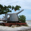
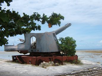
Tarawa - atoll in the Pacific Ocean - is the capital of Kiribati. Local landscapes are beautiful, but most of shore is heavily littered (as a result of overcrowding). It make sense to visit this place only if you are interested in military history. Famous Battle of Tarawa took place here in 1943. Few Japanese guns are located at Betio beach. Artifacts of that battle can be found in many other places. Beach and seabed: sand, stones. [edit]
Coordinates: 1.474813, 173.037337
See also: Best beaches in Tarawa island
Hotels [edit]
Local hotels are poorly presented in international booking systems. So we recommend to book well in advance.
How to get there [edit]
Fly to Tarawa International Airport (TRW). Next hire a taxi.
When to go [edit]
Try to avoid the rainy season, which lasts from December to May.Rainfall, mm

Water temperature, C
Temperature, C
Humidity, %
Wind speed, meter/sec
See also other islands nearby:
1790 km to the south ↓
1790 km to the south ↓