Island-on-Map.com The Free Beach Guide HomeCountriesMenu

Santa Rosa island

Ultimate guide (March 2024)
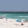
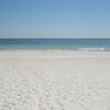
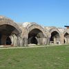
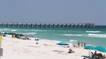
Santa Rosa - is a barrier island in Florida in the Gulf of Mexico. Beaches are beautiful here, though not so good as Caribbean beaches. There are also few notable attraction on the island like old Fort Pickens and Gulfarium Marine Adventure Park. Shore and seabed: sand. [edit]
This island ranks #2 of the "Best islands in Florida"
Rating: 7.9 - 547 votes [vote]
Coordinates: 30.375499, -86.900249
See also: Best beaches in Santa Rosa island

Hotels [edit]

There are no many hotels in the island, and they are rather expensive.

How to get there [edit]

Fly to Pensacola airport (PNS) or fly to Tampa international airport (TPA). Next rent a car.

When to go [edit]

Any time of the year. Keep in mind that it's rather cold here in winter.

Rainfall, mm
Rainfall, mm

Water temperature, C

Temperature, C
Temperature, C

Humidity, %
Humidity, %

Wind speed, meter/sec

Open map

See also other islands nearby:

 
USA, Florida Keys, Key West, Smathers beach 8.4
820 km to the south-east
Location: North America, USA, Florida
Rating: 8.4 (609 votes)
Grand Bahama island, Taino beach 8.1
930 km to the south-east
Location: Caribbean, Bahamas
Rating: 8.1 (747 votes)
Mexico, Isla Mujeres island, aerial view 7.7
1020 km to the south
Location: Central America, Mexico, Yucatan
Rating: 7.7 (252 votes)
Bahamas, Abaco Islands, Gillam Bay beach 8.0
1030 km to the east
Location: Caribbean, Bahamas
Rating: 8.0 (622 votes)
Mexico, Cozumel island, Faro Celerain Eco Park, lighthouse 7.5
1110 km to the south
Location: Central America, Mexico, Yucatan
Rating: 7.5 (332 votes)
💖
If you liked this page, please share it on: Facebook, Twitter, Instagram
…or any other web-site
 
This will help the project greatly!

 
To the top of this page »
 
© 2024, Island-on-Map.com · Menu