Island-on-Map.com The Free Beach Guide HomeCountriesMenu

Santa Catalina island

Ultimate guide (March 2024)
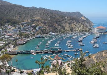
Santa Catalina - tourist island near Los Angeles. Beaches are mediocre here. Nevertheless, the island itself is beautiful. Beach and seabed: sand, stones. [edit]
This island ranks #3 of the "Best islands in the USA"
Rating: 7.2 - 1687 votes [vote]
Coordinates: 33.381786, -118.449685
See also: Best beaches in Santa Catalina island

Hotels [edit]

The island has a few dozen of hotels and all of them are located in Avalon.

How to get there [edit]

Fly to Los Angeles International Airport (LAX). There are ferries from Los Angeles to Avalon (from Long Beach, San Pedro, Newport Beach and from Dana Point) and to Two Harbors (from San Pedro).

When to go [edit]

Summer half of the year, as winter is too cold here. Keep in mind that sea water is rather cold even in August.

Rainfall, mm
Rainfall, mm

Water temperature, C

Temperature, C
Temperature, C

Humidity, %
Humidity, %

Wind speed, meter/sec

Open map

See also other islands nearby:

 
USA, California, Channel Islands, Santa Rosa 7.1
150 km to the north-west
Location: North America, USA, California
Rating: 7.1 (367 votes)
Canada, Vancouver island, mountain lake 6.9
1890 km to the north-west
Location: North America, Canada
Rating: 6.9 (632 votes)
USA, Florida, Santa Rosa island, Navarre Beach Park 7.9
2990 km to the east
Location: North America, USA, Florida, Emerald Coast
Rating: 7.9 (547 votes)
Mexico, Isla Mujeres island, aerial view 7.7
3400 km to the east
Location: Central America, Mexico, Yucatan
Rating: 7.7 (252 votes)
Mexico, Cozumel island, Faro Celerain Eco Park, lighthouse 7.5
3430 km to the east
Location: Central America, Mexico, Yucatan
Rating: 7.5 (332 votes)
💖
If you liked this page, please share it on: Facebook, Twitter, Instagram
…or any other web-site
 
This will help the project greatly!

 
To the top of this page »
 
© 2024, Island-on-Map.com · Menu