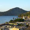
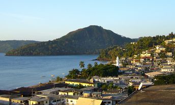
Island-on-Map.com The Free Beach Guide HomeCountriesMenu

Mayotte island

Ultimate guide (April 2024)
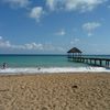
Mayotte (Mayotte) - island in the Indian Ocean - is a French Overseas Department since 2011. The standard of living is still low, though much work has beed done last years. Beaches are rather mediocre, but relatively good options can be found. Beach and seabed: sand, stones. [edit]
This island ranks #33 of the "Best islands in the Indian Ocean"
Rating: 7.7 - 713 votes [vote]
Coordinates: -12.820028, 45.153604
See also: Best beaches in Mayotte

Hotels [edit]

Island hotels are very poorly presented in international booking systems. Therefore, it is necessary to clearly understand where you will stay before you get to the island.

How to get there [edit]

Fly to Mayotte International Airport (DZA). Next hire a taxi.

When to go [edit]

Any time of year. Try to avoid the rainy season, which lasts from December to March.

Rainfall, mm
Rainfall, mm

Water temperature, C

Temperature, C
Temperature, C

Humidity, %
Humidity, %

Wind speed, meter/sec

Open map

See also other islands nearby:

 
Comoros, Anjouan island (Nzwani), ships in bay 7.6
100 km to the north-west
Location: Africa, Comoros
Rating: 7.6 (1055 votes)
Comoros, Moheli island (Mwali), aerial view 7.1
160 km to the west
Location: Africa, Comoros
Rating: 7.1 (732 votes)
Comoros, Grande Comore island, Chindini Beach 8.0
230 km to the north-west
Location: Africa, Comoros
Rating: 8.0 (729 votes)
Mozambique, Quirimbas, Vamizi Island 8.3
510 km to the west
Location: Africa, Mozambique
Rating: 8.3 (183 votes)
Madagascar island, Morondava, Avenue of the Baobabs 9.0
720 km to the south
Location: Africa
Rating: 9.0 (1544 votes)
💖
If you liked this page, please share it on: Facebook, Twitter, Instagram
…or any other web-site
 
This will help the project greatly!

 
To the top of this page »
 
© 2024, Island-on-Map.com · Menu