Island-on-Map.com The Free Beach Guide HomeCountriesMenu

Gozo island

Ultimate guide (April 2024)
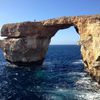
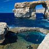
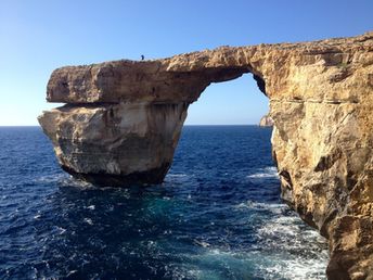
Gozo is the second largest island of Malta. There are no good beaches, nor significant attractions - as the famous arch of The Azure Window collapsed on March 8, 2017. Shore and seabed: rocks, sand. [edit]
This island ranks #2 of the "Best islands in Malta"
Rating: 6.8 - 432 votes [vote]
Coordinates: 36.047745, 14.255553
See also: Best beaches in Gozo island

Hotels [edit]

Most hotels are located inland. It's quite reasonable, as good beaches can't be found in the island.

How to get there [edit]

Fly to Malta International Airport (MLA). Next get by the ferry of Gozo Channel company. The ferry departs from ports of Cirkewwa (in the west of Malta island) and Sa Maison (Valletta), and arrives to Mgarr Harbour of Gozo island.

When to go [edit]

Summer half of the year.

Rainfall, mm
Rainfall, mm

Water temperature, C

Temperature, C
Temperature, C

Humidity, %
Humidity, %

Wind speed, meter/sec

Open map

See also other islands nearby:

 
Malta, Comino island, clear water 6.6
8.1 km to the south-east
Location: Europe, Malta
Rating: 6.6 (711 votes)
Malta Island, Valletta, Fort St. Elmo 7.6
23 km to the south-east
Location: Europe, Malta
Rating: 7.6 (3919 votes)
Italy, Lampedusa island, Rabbit Beach 7.8
160 km to the west
Location: Europe, Italy
Rating: 7.8 (1755 votes)
Italy, Sicily island, San Vito Lo Capo beach 8.2
160 km to the north
Location: Europe, Italy
Rating: 8.2 (1175 votes)
Italy, Pantelleria island, Specchio di Venere lake 7.0
220 km to the west
Location: Europe, Italy
Rating: 7.0 (410 votes)
💖
If you liked this page, please share it on: Facebook, Twitter, Instagram
…or any other web-site
 
This will help the project greatly!

 
To the top of this page »
 
© 2024, Island-on-Map.com · Menu