Island-on-Map.com The Free Beach Guide HomeCountriesMenu

Madagascar island

Ultimate guide (March 2024)
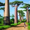
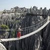
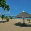
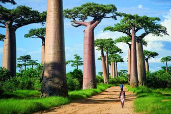
Madagascar - African island in the Indian Ocean. It is the country of baobabs and lemurs, as well as excellent beaches. Keep in mind that sometimes people are attacked by sharks - especially on the east coast. There are no much tourists due to the remoteness of the island. Shore and seabed: sand, stones. [edit]
This island ranks #18 of the "Best islands in the World"
Rating: 9.0 - 1524 votes [vote]
Coordinates: -19.101376, 46.856432
See also: Best beaches in Madagascar

Hotels [edit]

Hotels are located mainly in the capital and major tourist centers. On average, prices are not high.

How to get there [edit]

Fly to Antananarivo International Airport (TNR). There are also international flights to the islands of Nosy Be and Ile Sainte Marie.

When to go [edit]

The best time to visit Madagascar island is the dry season from April to November.

Rainfall, mm
Rainfall, mm

Water temperature, C

Temperature, C
Temperature, C

Humidity, %
Humidity, %

Wind speed, meter/sec

Open map

See also other islands nearby:

 
Mayotte island, Sada town 7.7
720 km to the north
Location: Indian Ocean
Rating: 7.7 (672 votes)
Comoros, Anjouan island (Nzwani), ships in bay 7.6
810 km to the north
Location: Africa, Comoros
Rating: 7.6 (1017 votes)
Comoros, Moheli island (Mwali), aerial view 7.1
820 km to the north-west
Location: Africa, Comoros
Rating: 7.1 (705 votes)
Comoros, Grande Comore island, Chindini Beach 8.0
910 km to the north-west
Location: Africa, Comoros
Rating: 8.0 (723 votes)
Reunion, helicopter in the mountains 7.5
930 km to the east
Location: Indian Ocean
Rating: 7.5 (1040 votes)
💖
If you liked this page, please share it on: Facebook, Twitter, Instagram
…or any other web-site
 
This will help the project greatly!

 
To the top of this page »
 
© 2024, Island-on-Map.com · Menu