Island-on-Map.com The Free Beach Guide HomeCountriesMenu

Katiu atoll

Ultimate guide (October 2025)
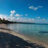
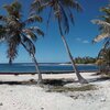
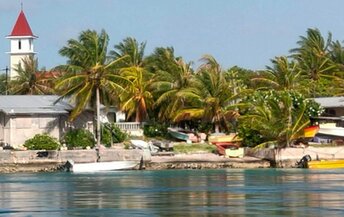
Katiu is an atoll to the east of Rangiroa Atoll, French Polynesia. Domestic flight connection is irregular and extremely rare, making it to be totally untouristic destination. In fact, there's nothing to do here. Beaches are rather mediocre by Polynesian standards. However, atoll's lagoon have some pleasant sandbanks. But there is nothing special about it. Shore and seabed: stones, sand. [edit]
This island ranks #30 of the "Best islands in French Polynesia"
Rating: 7.5 - 1 vote [vote]
Coordinates: -16.419469, -144.370761

Hotels [edit]

There are no hotels in the atoll of Katiu.

How to get there [edit]

Fly to Tahiti international airport (PPT), next fly to Katiu Airport (KXU/NTKT).

When to go [edit]

The best time for a beach holiday in Katiu atoll is a dry season from March to October.

Rainfall, mm
Rainfall, mm

Water temperature, C

Temperature, C
Temperature, C

Humidity, %
Humidity, %

Wind speed, meter/sec

Open map

See also other islands nearby:

 
French Polynesia, Raraka atoll 8.0
62 km to the north-west
Location: Oceania, French Polynesia
Rating: 8.0 (20 votes)
French Polynesia, Tahanea atoll 7.6
66 km to the south-west
Location: Oceania, French Polynesia
Rating: 7.6 (11 votes)
French Polynesia, Faaite atoll 7.8
100 km to the west
Location: Oceania, French Polynesia
Rating: 7.8 (18 votes)
French Polynesia, Kauehi atoll 8.1
100 km to the north-west
Location: Oceania, French Polynesia
Rating: 8.1 (15 votes)
French Polynesia, Fakarava Atoll 8.6
130 km to the west
Location: Oceania, French Polynesia
Rating: 8.6 (95 votes)
💖
If you liked this page, please share it on: Facebook, Twitter, Instagram
…or any other web-site
 
This will help the project greatly!

 
To the top of this page »
 
© 2025, Island-on-Map.com · Menu