
Gaua island
Ultimate guide (June 2026)
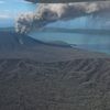
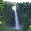
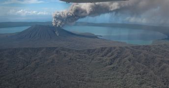
Gaua is an island in Vanuatu with Lake Letas being the largest one in the country. Another notable attraction is the Siri waterfall falling from a height of 120 meters. There are aborigines as well, but they don't perform any shows. There is even a beach (called Baravit) on the east coast, but it is rather mediocre. Shore and seabed: stones, sand. [edit]
Coordinates: -14.281748, 167.523536
Hotels [edit]
Gaua hotels are poorly presented in the online booking systems. In most cases, it is just a room in the local home.
How to get there [edit]
Fly to Port Vila international airport (VLI), then fly to Espiritu Santo airport (SON), and finally fly to Gaua airport (ZGU).
When to go [edit]
The best time for a beach holiday in the island of Gaua in Vanuatu is a dry period from July to October.Rainfall, mm

Water temperature, C
Temperature, C
Humidity, %
Wind speed, meter/sec
See also other islands nearby:
69 km to the north ↑
120 km to the south-east ↘
130 km to the south ↓