Island-on-Map.com The Free Beach Guide HomeCountriesMenu

Ambae island

Ultimate guide (July 2024)
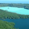
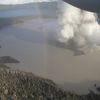
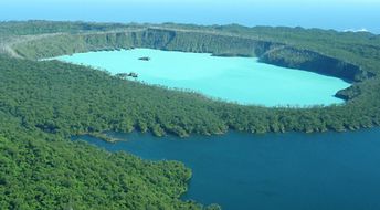
Ambae is an island in Vanuatu being relatively developed and not rich for the tourist attractions. There are two lakes, that cover the craters of volcanoes, but eruptions are rare. And after all, landscapes around the lakes are rather depressing. Shore and seabed: stones. [edit]
This island ranks #6 of the "Best Central Outer islands"
Rating: 7.8 - 621 votes [vote]
Coordinates: -15.392526, 167.841406

Hotels [edit]

On the island of Amba, there are not many accommodation options, and you are unlikely to find these over the Internet.

How to get there [edit]

Fly to Port Vila international airport (VLI), then fly to Espiritu Santo airport (SON), and finally fly to Longana airport (LOD).

When to go [edit]

The best time to relax on the beaches of Ambae in Vanuatu is a dry season from July to October.

Rainfall, mm
Rainfall, mm

Water temperature, C

Temperature, C
Temperature, C

Humidity, %
Humidity, %

Wind speed, meter/sec

Open map

See also other islands nearby:

 
Vanuatu, Maewo island, jump from waterfall 7.6
41 km to the north-east
Location: Oceania, Vanuatu, Central Outer islands
Rating: 7.6 (235 votes)
Vanuatu, Pentecost island, Land diving 8.7
57 km to the south-east
Location: Oceania, Vanuatu, Central Outer islands
Rating: 8.7 (519 votes)
Vanuatu, Ambrym island, volcano 8.5
100 km to the south
Location: Oceania, Vanuatu, Central Outer islands
Rating: 8.5 (287 votes)
Vanuatu, Espiritu Santo island, Port Olry Beach 8.6
100 km to the west
Location: Oceania, Vanuatu, Central Outer islands
Rating: 8.6 (420 votes)
Vanuatu, Malakula island 8.0
110 km to the south-west
Location: Oceania, Vanuatu, Central Outer islands
Rating: 8.0 (305 votes)
💖
If you liked this page, please share it on: Facebook, Twitter, Instagram
…or any other web-site
 
This will help the project greatly!

 
To the top of this page »
 
© 2024, Island-on-Map.com · Menu