Island-on-Map.com The Free Beach Guide HomeCountriesMenu

Futuna island

Ultimate guide (April 2024)
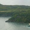
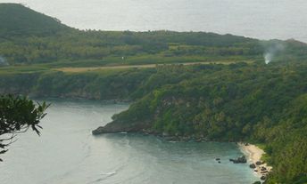
Futuna (West Futuna) is the easternmost island in Vanuatu, notable mainly for its Polynesian population. There is nothing like a tourist infrastructure, so the main attraction is hiking around the scenic hills. There are also some beaches and snorkeling. Shore and seabed: sand, stones. [edit]
This island ranks #4 of the "Best Tafea islands"
Rating: 7.2 - 239 votes [vote]
Coordinates: -19.529748, 170.217393

Hotels [edit]

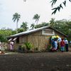
There are no hotels in Futuna. The only accommodation option is to stay at local home. So it is worth to take with you money, as well as food, drinks, matches and other gifts, that can be useful for the locals.

How to get there [edit]

Fly to Port Vila international airport (VLI), next fly to Futuna airport (FTA) (via Tanna or via Aniwa).

When to go [edit]

The best time to relax on the beaches of Futuna in Vanuatu is a dry season from July to October.

Rainfall, mm
Rainfall, mm

Water temperature, C

Temperature, C
Temperature, C

Humidity, %
Humidity, %

Wind speed, meter/sec

Open map

See also other islands nearby:

 
Vanuatu, Aniwa lagoon 7.8
72 km to the north-west
Location: Oceania, Vanuatu, Tafea
Rating: 7.8 (228 votes)
Vanuatu, Aneityum, Mystery Island, beach 8.4
85 km to the south-west
Location: Oceania, Vanuatu, Tafea
Rating: 8.4 (399 votes)
Vanuatu, Tanna island, locals 8.8
90 km to the west
Location: Oceania, Vanuatu, Tafea
Rating: 8.8 (510 votes)
Vanuatu, Erromango island, beach 7.1
130 km to the north-west
Location: Oceania, Vanuatu, Tafea
Rating: 7.1 (475 votes)
Vanuatu, Efate island, Kakula beach 8.3
280 km to the north-west
Location: Oceania, Vanuatu
Rating: 8.3 (367 votes)
💖
If you liked this page, please share it on: Facebook, Twitter, Instagram
…or any other web-site
 
This will help the project greatly!

 
To the top of this page »
 
© 2024, Island-on-Map.com · Menu