Island-on-Map.com The Free Beach Guide HomeCountriesMenu

Erromango island

Ultimate guide (April 2024)
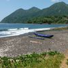
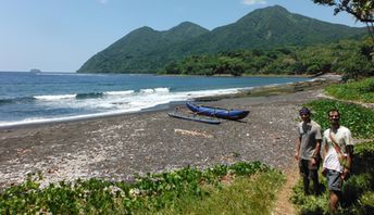
Erromango is one of the least interesting islands in Vanuatu. There is not a single attraction worth to mention. Therefore, rare tourists have the only thing to do - walking around the mountains or by the sea. Shore and seabed: stones, sand. [edit]
This island ranks #5 of the "Best Tafea islands"
Rating: 7.1 - 475 votes [vote]
Coordinates: -18.823156, 169.176514

Hotels [edit]

There are several guesthouses on the island of Eromango. These are mainly hosted in the towns of Dillon's Bay and Ipota.

How to get there [edit]

Fly to Port Vila international airport (VLI), then fly to Dillon's Bay airport (DLY) or fly to Ipota airport (IPA).

When to go [edit]

The best time for a beach holiday in the island of Erromango is a dry season from July to October.

Rainfall, mm
Rainfall, mm

Water temperature, C

Temperature, C
Temperature, C

Humidity, %
Humidity, %

Wind speed, meter/sec

Open map

See also other islands nearby:

 
Vanuatu, Aniwa lagoon 7.8
65 km to the south-east
Location: Oceania, Vanuatu, Tafea
Rating: 7.8 (228 votes)
Vanuatu, Tanna island, locals 8.8
78 km to the south
Location: Oceania, Vanuatu, Tafea
Rating: 8.8 (510 votes)
Vanuatu, Futuna island 7.2
130 km to the south-east
Location: Oceania, Vanuatu, Tafea
Rating: 7.2 (239 votes)
Vanuatu, Efate island, Kakula beach 8.3
160 km to the north-west
Location: Oceania, Vanuatu
Rating: 8.3 (367 votes)
Vanuatu, Aneityum, Mystery Island, beach 8.4
170 km to the south-east
Location: Oceania, Vanuatu, Tafea
Rating: 8.4 (399 votes)
💖
If you liked this page, please share it on: Facebook, Twitter, Instagram
…or any other web-site
 
This will help the project greatly!

 
To the top of this page »
 
© 2024, Island-on-Map.com · Menu