Zanzibar island
Ultimate guide (June 2026)
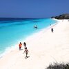
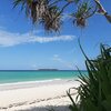
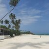
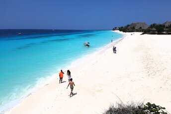
Zanzibar is an island in the Indian Ocean, located near the mainland of Tanzania. Excellent white beaches are the main goal of the island. Stone Town old streets are also notable attraction and were included into UNESCO World Heritage Site. Beach and seabed: sand. [edit]
Coordinates: -6.119175, 39.354200
See also: Best beaches in Zanzibar
Hotels [edit]
Beach resorts are rather expensive, though sometimes there are pretty exceptions. Stone Town has lots of cheap hotels, but unfortunately there's no good beach in the town area.
How to get there [edit]
Fly to Zanzibar International Airport (ZNZ). Then take a taxi. Public transport on the island is undeveloped, and we don't recommend to rely on it.Sometimes it may be cheaper first fly to Dar es Salaam International Airport (DAR), and next get to Zanzibar by ferry or by plane.
When to go [edit]
Any time, except for the rainy season in April-May. Also try to avoid the small rainy season in November-December.Rainfall, mm

Water temperature, C
Temperature, C
Humidity, %
Wind speed, meter/sec
Useful information [edit]
Evening market in Forodhani Gardens (Stone Town) has take-away food at the cheapest price on the island. We recommend to taste delicious seafood.