Island-on-Map.com The Free Beach Guide HomeCountriesMenu

Whitsunday island

Ultimate guide (April 2024)
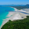
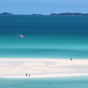
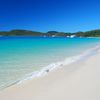
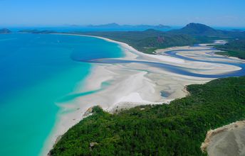
Whitsunday - island of the Great Barrier Reef in Australia famous for Whitehaven Beach with white sand sandbanks. Beach and seabed: sand. [edit]
This island ranks #2 of the "Best islands in Whitsunday Coast"
Rating: 8.2 - 742 votes [vote]
Coordinates: -20.253823, 148.982795
See also: Best beaches in Whitsunday island

Hotels [edit]

On the island, you can only live in a tent in one of the numerous campgrounds. You may also stay in a hotel in Airlie Beach city located on the mainland.

How to get there [edit]

Fly to Proserpine / Whitsunday Coast Airport (PPP). Hire a taxi to Airlie Beach city. There are many boats form town to the island.

When to go [edit]

From January to March the water is warm, but it's rainy. The least amount of rain - from June to November, but the water at this period is pretty cool.

Rainfall, mm
Rainfall, mm

Water temperature, C

Temperature, C
Temperature, C

Humidity, %
Humidity, %

Wind speed, meter/sec

Open map

See also other islands nearby:

 
Whitsunday Coast, Hamilton island, Catseye Beach 8.4
11 km to the south
Location: Oceania, Australia, Whitsunday Coast
Rating: 8.4 (214 votes)
Australia, Townsville, Magnetic island 8.1
260 km to the north-west
Location: Oceania, Australia, Townsville
Rating: 8.1 (218 votes)
Australia, Bedarra island, beach 8.1
390 km to the north-west
Location: Oceania, Australia, Cairns region, Mission beach
Rating: 8.1 (376 votes)
Australia, Dunk Island 7.7
390 km to the north-west
Location: Oceania, Australia, Cairns region, Mission beach
Rating: 7.7 (374 votes)
Australia, Heron Island 8.3
470 km to the south-east
Location: Oceania, Australia, Capricorn Group
Rating: 8.3 (358 votes)
💖
If you liked this page, please share it on: Facebook, Twitter, Instagram
…or any other web-site
 
This will help the project greatly!

 
To the top of this page »
 
© 2024, Island-on-Map.com · Menu