Island-on-Map.com The Free Beach Guide HomeCountriesMenu

Viti Levu island

Ultimate guide (March 2024)
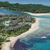
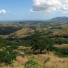
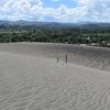
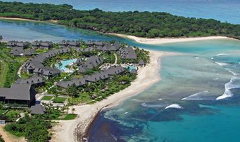
Viti Levu - is the main island of Fiji. There is an international airport, as well as the largest cities in the country. Island beaches are not very good, but there are many interesting attractions, - Sigatoka Sand Dunes, Navua river with beautiful canyons and many more. Shore and seabed: rocks, sand. [edit]
This island ranks #3 of the "Best islands in Fiji"
Rating: 8.5 - 785 votes [vote]
Coordinates: -17.781434, 178.022723
See also: Best beaches in Viti Levu island

Hotels [edit]

Local hotels are generally cheaper than those at small remote islands, but still overpriced. Good news is that you won't be forced to take hotel's full board meal plan, like they love to do in most of the Yasawa Islands.

How to get there [edit]

Fly to Nadi International Airport (NAN). Follow by a taxi or by bus.

When to go [edit]

Fiji has great weather all year round. But it's best to choose the dry season from May to November.

Rainfall, mm
Rainfall, mm

Water temperature, C

Temperature, C
Temperature, C

Humidity, %
Humidity, %

Wind speed, meter/sec

Open map

See also other islands nearby:

 
Fiji, Mamanuca Islands, Tavarua island 8.6
91 km to the west
Location: Oceania, Fiji
Rating: 8.6 (533 votes)
Fiji, Vatulele island, beach 8.4
91 km to the south-west
Location: Oceania, Fiji
Rating: 8.4 (597 votes)
Fiji, Yasawa Islands, Nanuya Lailai island, Blue Lagoon beach 9.1
110 km to the north-west
Location: Oceania, Fiji
Rating: 9.1 (414 votes)
Fiji, Lomaivitis, Leleuvia island, beach, palm 8.1
120 km to the east
Location: Oceania, Fiji
Rating: 8.1 (168 votes)
Fiji, Kadavu islands, beach, palm over water 8.3
140 km to the south
Location: Oceania, Fiji
Rating: 8.3 (262 votes)
💖
If you liked this page, please share it on: Facebook, Twitter, Instagram
…or any other web-site
 
This will help the project greatly!

 
To the top of this page »
 
© 2024, Island-on-Map.com · Menu