Island-on-Map.com The Free Beach Guide HomeCountriesMenu

Vatulele island

Ultimate guide (April 2024)
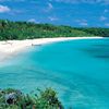
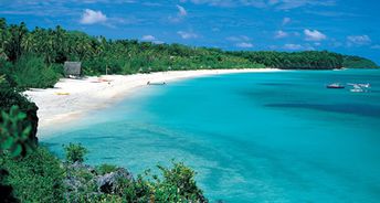
Vatulele is an island located just south of the main island of Viti Levu in Fiji. The island has four villages, nice beaches and even some ancient archaeological sites. Shore and seabed: sand, stones. [edit]
This island ranks #6 of the "Best islands in Fiji"
Rating: 8.4 - 630 votes [vote]
Coordinates: -18.502542, 177.614475

Hotels [edit]

Vatulele Island Resort is a luxury eco-hotel focused on honeymooners. It's a strange Fijian tradition, but children are not allowed into such hotels.

How to get there [edit]

Fly to Nadi International Airport (NAN). Next follow by a helicopter, or by a seaplane, or by a private speed boat.

When to go [edit]

The best time to travel to the island of Vatulele is a dry season from May to November.

Rainfall, mm
Rainfall, mm

Water temperature, C

Temperature, C
Temperature, C

Humidity, %
Humidity, %

Wind speed, meter/sec

Open map

See also other islands nearby:

 
Fiji, Kadavu islands, beach, palm over water 8.3
88 km to the south-east
Location: Oceania, Fiji
Rating: 8.3 (270 votes)
Fiji, Viti Levu island, aerial view to Intercontinental hotel 8.5
91 km to the north-east
Location: Oceania, Fiji
Rating: 8.5 (790 votes)
Fiji, Mamanuca Islands, Tavarua island 8.6
110 km to the north-west
Location: Oceania, Fiji
Rating: 8.6 (538 votes)
Fiji, Yasawa Islands, Nanuya Lailai island, Blue Lagoon beach 9.1
160 km to the north
Location: Oceania, Fiji
Rating: 9.1 (422 votes)
Fiji, Lomaivitis, Leleuvia island, beach, palm 8.1
180 km to the north-east
Location: Oceania, Fiji
Rating: 8.1 (172 votes)
💖
If you liked this page, please share it on: Facebook, Twitter, Instagram
…or any other web-site
 
This will help the project greatly!

 
To the top of this page »
 
© 2024, Island-on-Map.com · Menu