Island-on-Map.com The Free Beach Guide HomeCountriesMenu

Vanua Levu island

Ultimate guide (July 2024)
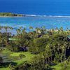
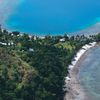
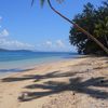
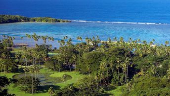
Vanua Levu is the second largest island in Fiji. There are no many good beaches, and no many attractions. The entire island is surrounded in a lush tropical greenery, and it's a paradise for eco-tourists. Shore and seabed: rocks, sand. [edit]
This island ranks #10 of the "Best islands in Fiji"
Rating: 7.6 - 341 votes [vote]
Coordinates: -16.605319, 179.299682
See also: Best beaches in Vanua Levu island

Hotels [edit]

The island has no many hotels, and these are not cheap (like everywhere in Fiji). So it is better to book in advance.

How to get there [edit]

Fly to Nadi International Airport (NAN). Then take a ferry from Ellington Wharf or from Natovi Landing to the port of Nabouwalu. There is also flight cannection between the islands, but prices are high.

When to go [edit]

The best time to travel to the island of Vanua Levu is a dry season from May to November.

Rainfall, mm
Rainfall, mm

Water temperature, C

Temperature, C
Temperature, C

Humidity, %
Humidity, %

Wind speed, meter/sec

Open map

See also other islands nearby:

 
Fiji, Taveuni island, beach, palms 8.3
91 km to the east
Location: Oceania, Fiji
Rating: 8.3 (840 votes)
Fiji, Lomaivitis, Leleuvia island, beach, palm 8.1
130 km to the south
Location: Oceania, Fiji
Rating: 8.1 (183 votes)
Fiji, Viti Levu island, aerial view to Intercontinental hotel 8.5
190 km to the south-west
Location: Oceania, Fiji
Rating: 8.5 (818 votes)
Fiji, Yasawa Islands, Nanuya Lailai island, Blue Lagoon beach 9.1
220 km to the west
Location: Oceania, Fiji
Rating: 9.1 (442 votes)
Fiji, Lau islands, Vatuvara, aerial view 8.4
Lau / open » /
250 km to the south-east
Location: Oceania, Fiji
Rating: 8.4 (1004 votes)
💖
If you liked this page, please share it on: Facebook, Twitter, Instagram
…or any other web-site
 
This will help the project greatly!

 
To the top of this page »
 
© 2024, Island-on-Map.com · Menu