Rakahanga atoll
Ultimate guide (June 2026)
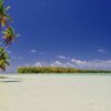
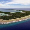
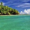
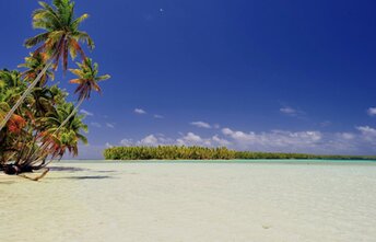
Rakahanga is an atoll in the north of the Cook Islands. It has an unusual rectangular shape. While its lagoon is great for island hopping even without any "tours". In fact, it is possible just to walk from one motu to another. Inner beaches of the lagoon are beautiful with many palms. But sea bottom is mostly rocky. Nivano village is not very interesting. But this still is an authentic Polynesia being unspoiled by the mass tourism. So it is worth a visit anyway. Shore and seabed: stones, sand. [edit]
Coordinates: -10.016598, -161.090723
Hotels [edit]
There are no hotels in Rakahanga. It makes sense to contact the atoll administration (better in advance) to find for you a local family ready to give you a room in their home. It is also possible to spend a night in your own tent. But there is no reliable information about such an experience.
How to get there [edit]
Fly to Rarotonga international airport (RAR), next fly to Manihiki airport. Next get by ferry to Rakahanga atoll. There is no regular timetable of the ferry. So it is almost impossible to plan the trip much in advance.
When to go [edit]
The best time for a holiday in Rakahanga atoll is a dry season from June to December.Rainfall, mm

Water temperature, C
Temperature, C
Humidity, %
Wind speed, meter/sec