Ambergris Caye island
Ultimate guide (June 2026)
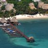
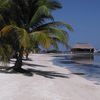
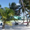
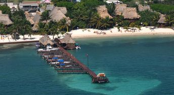
Ambergris Caye - is a popular tourist island in the Caribbean Sea in the north of Belize. Local beaches are probably not the best in the Caribbean, but very nice. The main problem here is seagrass in the water. Shore and seabed: sand, coral chips. [edit]
Coordinates: 18.020983, -87.90953
See also: Best beaches in Ambergris Caye island
Hotels [edit]
Most of island hotels are very expensive and obviously focused on rich American tourists. However, you can find in San Pedro few budget accommodation options.
How to get there [edit]
Fly to Belize International Airport (BZE). Next fly to San Pedro Airport (SPR).Ambergris Caye island also can be reached by water from: 1. Chetumal (Mexico), 2. Belize City, 3. Caye Caulker, 4. Corozal.
When to go [edit]
The best time for a holiday in Belize is a dry season from mid-January to May.Rainfall, mm

Water temperature, C
Temperature, C
Humidity, %
Wind speed, meter/sec
Useful information [edit]
It is common to believe that Madonna in her genious song "La Isla Bonita" in 1986 sang about the island of Ambergris Caye. However, the singer has never given a clear interpretation in this issue. See also other islands nearby:
87 km to the south-east ↘
180 km to the south ↓
240 km to the south-east ↘