Utila island
Ultimate guide (June 2026)
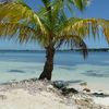
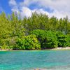
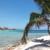
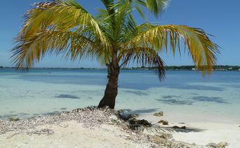
Utila is an island in the Caribbean Sea, not far from the mainland of Honduras. It makes interest mainly for divers, as a good entry point to the Mesoamerican Barrier Reef. However, there are also few good beaches, - both on the main island, as well as in the tiny neighbouring islets. Shore and seabed: sand, stones. [edit]
Coordinates: 16.089686, -86.939234
See also: Best beaches in Utila island
Hotels [edit]
The number of hotels on the island is extremely limited, so we recommend to book in advance. Please note that only hotels of the Big Island are presented in the international reservation systems.
How to get there [edit]
Fly to La Ceiba Airport (LCE). Next get to Muelle de Cabotaje port, and then sail to the Utila island. The ferry leaves twice a day, takes 1 hour and costs about $25 one way (children under 12 years - 2 times cheaper, children under 5 years - free).Another option is to fly to the airport of Roatan island (RTB). There is a ferry to the Utila island. One way also takes about 1 hour. But the last years flights from Roatan to Utila became even more reliable than the ferry transportation.
When to go [edit]
The best time to travel to the Utila island is a dry season from March to August. On the other hand the period from October to December is very bad due to the heavy rainfall.Rainfall, mm

Water temperature, C
Temperature, C
Humidity, %
Wind speed, meter/sec
See also other islands nearby:
66 km to the north-east ↗
140 km to the west ←
150 km to the north-west ↖