Island-on-Map.com The Free Beach Guide HomeCountriesMenu

Geojedo island

Ultimate guide (April 2024)
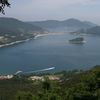
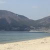
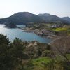
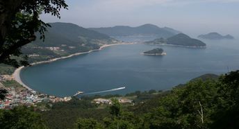
Geojedo - is an island located south-west of Busan. There are a few good beaches, but the whole island is not very interesting. Shore and seabed: sand, stones. [edit]
This island ranks #3 of the "Best islands in South Korea"
Rating: 4.7 - 390 votes [vote]
Coordinates: 34.864709, 128.626167
See also: Best beaches in Geojedo island

Hotels [edit]

Geojedo island has a good choice of hotels, though not comparable to Busan.

How to get there [edit]

Fly to Busan International Airport (PUS). Next hire a taxi.

When to go [edit]

It is the best to visit Busan in the summer half of the year, as the winter is too cold here.

Rainfall, mm
Rainfall, mm

Water temperature, C

Temperature, C
Temperature, C

Humidity, %
Humidity, %

Wind speed, meter/sec

Open map

See also other islands nearby:

 
South Korea, Udo island 6.6
Udo / open » /
220 km to the south-west
Location: Eastern Asia, South Korea
Rating: 6.6 (935 votes)
South Korea, Jeju island, Jungmun Beach 7.3
250 km to the south-west
Location: Eastern Asia, South Korea
Rating: 7.3 (891 votes)
Japan, Amami, Kakeromajima island, beach 7.8
750 km to the south
Location: Eastern Asia, Japan, Amami
Rating: 7.8 (245 votes)
Japan, Amami, Tokunoshima island 7.6
790 km to the south
Location: Eastern Asia, Japan, Amami
Rating: 7.6 (299 votes)
Japan, Amami, Okinoerabu island 7.4
830 km to the south
Location: Eastern Asia, Japan, Amami
Rating: 7.4 (193 votes)
💖
If you liked this page, please share it on: Facebook, Twitter, Instagram
…or any other web-site
 
This will help the project greatly!

 
To the top of this page »
 
© 2024, Island-on-Map.com · Menu