Island-on-Map.com The Free Beach Guide HomeCountriesMenu

Avsa island

Ultimate guide (April 2024)
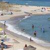
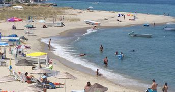
Avsa - is a popular tourist island in the Marmara Sea near Istanbul. It is best to walk around the pretty hills of the island making stops at secluded bays with excellent beaches. However, most of the people stay in the main Avsa town. Shore and seabed: sand. [edit]
This island ranks #7 of the "Best islands in Western Asia"
Rating: 7.0 - 2897 votes [vote]
Coordinates: 40.502573, 27.510426

Hotels [edit]

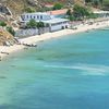
Most of the hotels are located on the west of the island in Avsa village. It is best to rent a room here.

How to get there [edit]

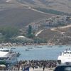
Fly to Istanbul International Airport (IST). There is a good ferry connectin between Istanbul and Avsa island (4 hours per way) during the summer time. You can move around the island by buses or just walking.

When to go [edit]

The best time for a beach holiday in the Sea of Marmara is a period from June to September.

Rainfall, mm
Rainfall, mm

Water temperature, C

Temperature, C
Temperature, C

Humidity, %
Humidity, %

Wind speed, meter/sec

Open map

See also other islands nearby:

 
Turkey, Sedir island, acient ruins 6.9
400 km to the south
Location: Western Asia, Turkey
Rating: 6.9 (669 votes)
Greece, Santorini island 8.3
490 km to the south-west
Location: Europe, Greece
Rating: 8.3 (691 votes)
Greece, Crete island, Preveli beach 8.1
630 km to the south-west
Location: Europe, Greece
Rating: 8.1 (320 votes)
Cyprus island, Mimosa beach 7.9
790 km to the south-east
Location: Europe
Rating: 7.9 (229 votes)
Croatia, Hvar island, Dubovica 7.6
930 km to the west
Location: Europe, Croatia
Rating: 7.6 (411 votes)
💖
If you liked this page, please share it on: Facebook, Twitter, Instagram
…or any other web-site
 
This will help the project greatly!

 
To the top of this page »
 
© 2024, Island-on-Map.com · Menu