Island-on-Map.com The Free Beach Guide HomeCountriesMenu

Atiu island

Ultimate guide (April 2024)
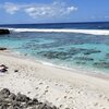
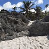
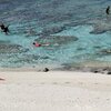
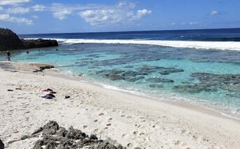
Atiu is a small island located relatively close to the main airport of Cook Islands. Unfortunately, there are no good beaches. Matai Beach in the southeast is the most popular swimming spot. The main village is located in the center of the island. So you can walk around the whole island, which is relatively small. Shore and seabed: stones, sand. [edit]
This island ranks #6 of the "Best atolls in Cook Islands"
Rating: 8.1 - 92 votes [vote]
Coordinates: -19.996055, -158.113635

Hotels [edit]

Atiu Villas is a three-star property with rooms' rates starting from US$150 per night. You'll have a separate bungalow, as well as a swimming pool and a tennis court.

How to get there [edit]

Fly to Rarotonga international airport (RAR), and next fly to Atiu island airport (AIU).

When to go [edit]

The best time for a beach holiday in the Cook Islands is a dry season from June to October.

Rainfall, mm
Rainfall, mm

Water temperature, C

Temperature, C
Temperature, C

Humidity, %
Humidity, %

Wind speed, meter/sec

Open map

See also other islands nearby:

 
Cook Islands, Mitiaro island, beach 5.8
45 km to the east
Location: Oceania, Cook Islands
Rating: 5.8 (41 votes)
Cook Islands, Mauke island, Anaokae beach 7.5
83 km to the east
Location: Oceania, Cook Islands
Rating: 7.5 (54 votes)
Cook Islands, atoll Aitutaki, aerial view 9.4
210 km to the north-west
Location: Oceania, Cook Islands
Rating: 9.4 (2264 votes)
Cook Islands, Mangaia, beach 7.7
220 km to the south
Location: Oceania, Cook Islands
Rating: 7.7 (109 votes)
Cook Islands, Rarotonga island, Little Polynesian Resort beach 8.3
220 km to the south-west
Location: Oceania, Cook Islands
Rating: 8.3 (651 votes)
💖
If you liked this page, please share it on: Facebook, Twitter, Instagram
…or any other web-site
 
This will help the project greatly!

 
To the top of this page »
 
© 2024, Island-on-Map.com · Menu