Island-on-Map.com The Free Beach Guide HomeCountriesMenu

Angaur island

Ultimate guide (June 2025)
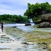
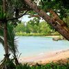
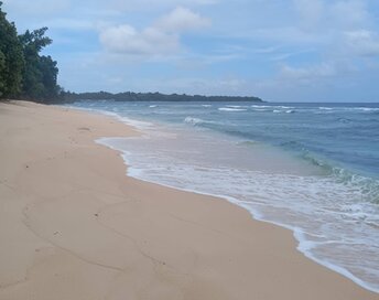
Angaur is the southernmost island of Palau. There are just a few good beaches, while attractions are limited. In fact, it is only worth to visit old lighthouse on the mountain - to watch the view from above. As for churches and cemeteries, these are definitely not worth a trip to this remote island. Shore and seabed: sand, stones. [edit]
This island ranks #8 of the "Best islands in Palau"
Rating: 8.1 - 1 vote [vote]
Coordinates: 6.906624, 134.135829

Hotels [edit]

There are few hotels on Angaur Island. But these are almost not presented on Internet. Rooms' fares start from US$100 per night.

How to get there [edit]

Fly to Palau international airport (ROR). Next fly to Angaur airport (ANG).

When to go [edit]

The best time for a beach holiday in Palau is a dry season from February to April.

Rainfall, mm
Rainfall, mm

Water temperature, C

Temperature, C
Temperature, C

Humidity, %
Humidity, %

Wind speed, meter/sec

Open map

See also other islands nearby:

 
Palau, Peleliu island, beach 7.5
18 km to the north-east
Location: Oceania, Palau
Rating: 7.5 (7 votes)
Palau, Carp Island 8.3
26 km to the north-east
Location: Oceania, Palau
Rating: 8.3 (7 votes)
Palau, Ngemelis islands 8.9
26 km to the north-east
Location: Oceania, Palau
Rating: 8.9 (27 votes)
Palau, Uncle Island, beach 8.1
32 km to the north-east
Location: Oceania, Palau
Rating: 8.1 (16 votes)
Palau, Omekang island 8.4
33 km to the north-east
Location: Oceania, Palau
Rating: 8.4 (39 votes)
💖
If you liked this page, please share it on: Facebook, Twitter, Instagram
…or any other web-site
 
This will help the project greatly!

 
To the top of this page »
 
© 2025, Island-on-Map.com · Menu