Island-on-Map.com The Free Beach Guide HomeCountriesMenu

Peleliu island

Ultimate guide (May 2025)
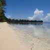
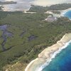
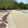
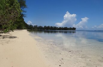
Peleliu is a large island in the south of Palau. During World War II, it was an epic battle here between Americans and Japanese. Unfortunately, there is not much to see now except for the memorials. As for the beaches, there is nothing to speak of. Some coastal areas are quite beautiful. But swimming is impossible, since sea bottom is either rocky or too shallow. Shore and seabed: sand, stones. [edit]
This island ranks #12 of the "Best islands in Palau"
Rating: 7.5 - 4 votes [vote]
Coordinates: 7.021401, 134.252602

Hotels [edit]

There is a limited choice of hotels in Peleliu Island. The best is to try airbnb.

How to get there [edit]

Fly to Palau international airport (ROR). Next take a taxi or get by bus to the neighboring island of Koror. Next get by boat to Peleliu island.

When to go [edit]

The best time for a beach holiday in Palau is a dry season from February to April.

Rainfall, mm
Rainfall, mm

Water temperature, C

Temperature, C
Temperature, C

Humidity, %
Humidity, %

Wind speed, meter/sec

Open map

See also other islands nearby:

 
Palau, Carp Island 8.3
7.9 km to the north
Location: Oceania, Palau
Rating: 8.3 (5 votes)
Palau, Ngemelis islands 8.8
9.9 km to the north
Location: Oceania, Palau
Rating: 8.8 (21 votes)
Palau, Uncle Island, beach 8.1
14 km to the north-east
Location: Oceania, Palau
Rating: 8.1 (15 votes)
Palau, Omekang island 8.4
15 km to the north-east
Location: Oceania, Palau
Rating: 8.4 (32 votes)
Palau, Ngerukewid islands 7.7
17 km to the north
Location: Oceania, Palau
Rating: 7.7 (14 votes)
💖
If you liked this page, please share it on: Facebook, Twitter, Instagram
…or any other web-site
 
This will help the project greatly!

 
To the top of this page »
 
© 2025, Island-on-Map.com · Menu