Island-on-Map.com The Free Beach Guide HomeCountriesMenu

St. John island

Ultimate guide (March 2024)
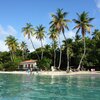
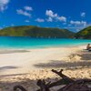
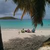
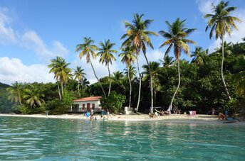
St. John - island with best beaches in American Virgin Islands. Much of the island is a National Park. Beach: sand. Seabed: sand, stones. [edit]
This island ranks #13 of the "Best islands in the Caribbean"
Rating: 8.7 - 683 votes [vote]
Coordinates: 18.337417, -64.733704
See also: Best beaches in St. John island

Hotels [edit]

There are very few hotels on the island. So it makes sense to live in the neighboring St. Thomas island and make daily boat trips to St. John island.

How to get there [edit]

Fly to St. Thomas airport (STT). (In most cases, it will be cheaper to fly via San Juan airport (SJU).) Get by shuttle bus from St. Thomas airport to Red Hook ferry pier. Next take a boat to Cruz Bay of St. John island.

When to go [edit]

Any time of year. The winter half of the year features by the greatest number of tourists on the island.

Rainfall, mm
Rainfall, mm

Water temperature, C

Temperature, C
Temperature, C

Humidity, %
Humidity, %

Wind speed, meter/sec

Open map

See also other islands nearby:

 
British Virgin Islands (BVI), Jost Van Dyke island, White Bay 8.9
12 km to the north
Location: Caribbean, BVI
Rating: 8.9 (718 votes)
BVI, Tortola island, Cane Garden Bay beach 8.6
15 km to the north-east
Location: Caribbean, BVI
Rating: 8.6 (198 votes)
American Virgin Islands (USVI), St. Thomas island, Lindberg Bay beach 8.2
21 km to the west
Location: Caribbean, USVI
Rating: 8.2 (689 votes)
BVI, Beef Island, Tortola airport, aerial view 8.3
24 km to the north-east
Location: Caribbean, BVI
Rating: 8.3 (555 votes)
BVI, Virgin Gorda island, Savannah Bay beach 8.6
40 km to the east
Location: Caribbean, BVI
Rating: 8.6 (60 votes)
💖
If you liked this page, please share it on: Facebook, Twitter, Instagram
…or any other web-site
 
This will help the project greatly!

 
To the top of this page »
 
© 2024, Island-on-Map.com · Menu