Bequia island
Ultimate guide (June 2026)
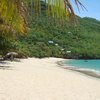
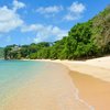
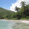
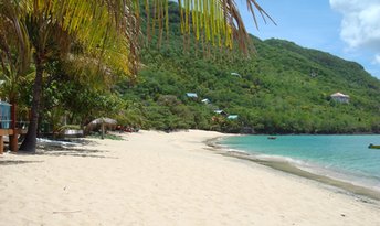
Bequia is the northernmost island of the Grenadines being the closest one to the south of Saint Vincent (the main country's island). This is a small Caribbean island having all that we might expect from it. There are several different beaches with white sand, trees and palms. But if you get tired of beaches, there are also many rocky spots with "dramatic" scenery. So the place is good enough even to get some cruise ships traffic (fortunately, very limited). Shore and seabed: sand, stones. [edit]
Coordinates: 13.013026, -61.235924
See also: Best beaches in Bequia island
Hotels [edit]
As for the hotels, Bequia is no different from other Antilles islands. Rooms' fares start from as low as US$50. While for about US$100-200 per night, it is possible to find very good beachfront resorts.
How to get there [edit]
Fly to Saint Vincent international airport (SVD). Next fly to Bequia island airport (BQU).There is also ferry services between the islands of Saint Vincent (Kingstown port) and Bequia (Port Elizabeth). It takes 30-50 minutes per way. No need to purchase tickets in advance:
- Bequia Express, US$10 per person, discounted fares for children;
- Admiral Ferries / Admiralty Transport, fares are the same as Bequia Express, but they offer a larger and more comfortable ship called Admiral II.
You may also visit other Grenadines islets from Bequia island by a domestic flight or by Bequia Friendship Rose sailboat (adult from US$130 per day, discounts for children).
There is also mail boat running between Bequia, Canouan, Mayreau and Union islands. But this option is very hard in all respects.
When to go [edit]
The best time for a beach holiday in Bequia Island is a dry season from December to May.Rainfall, mm

Water temperature, C
Temperature, C
Humidity, %
Wind speed, meter/sec